

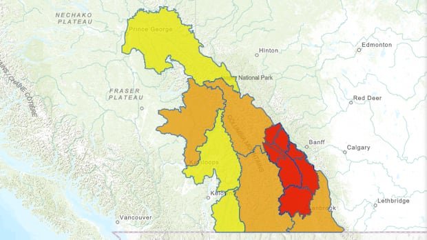

The flood warning previously issued for the Upper Columbia region, Kootenay River area, and Lardeau River has now been lowered to a flood watch. In addition, the flood watch for the North Thompson River and West Kootenay regions has been reduced to a high streamflow advisory, while the high streamflow advisory for the South Thompson and Boundary regions has been lifted.
Despite these changes, flood alerts persist across much of British Columbia’s southern Interior, resulting in over 150 properties being placed under evacuation alert. The Regional District of East Kootenay recently issued an evacuation alert for 97 properties, including various stratas and campsites along Fairmont Creek in the southeastern part of the province. This alert was prompted by sustained rainfall, which raised concerns about potential debris flooding or debris flow in the area.
Although Fairmont Creek has not overflowed its banks, the district highlighted that upper debris traps are filling up with debris, and more rain is anticipated in the upcoming days. The River Forecast Centre has cautioned about significant snowmelt due to warm weather conditions, coupled with expected heavy rainfall in the region.
Notably, the Upper Columbia and Kootenay River areas are currently under a flood warning, indicating that river levels have surpassed bankfull levels or are on the verge of doing so, leading to potential flooding in adjacent areas. Meanwhile, the North Thompson River, West Kootenay, and East Kootenay areas south of Invermere are under a flood watch, signifying rising river levels nearing bankfull capacity. The Upper Fraser, South Thompson, and Boundary regions are under a high streamflow advisory, suggesting the possibility of minor flooding in low-lying areas as river levels rise, but without any major flooding anticipated.
Furthermore, nearly 200 homes across various communities along the Lardeau and Duncan rivers in the Central Kootenay area are under evacuation alert. This includes areas like Cooper Creek, Meadow Creek, Marblehead, and Poplar Creek, where the rapid rise in river levels poses a risk of exceeding bank capacity. Additionally, six properties in Golden, B.C., have been under evacuation alert since Friday afternoon.
A water quality advisory has been issued for Edgewater, B.C., a small unincorporated settlement with around 700 residents. The Regional District of East Kootenay has alerted residents about high water turbidity resulting from spring runoff, advising children, the elderly, and individuals with weakened immune systems to consume boiled water or seek a safe alternative.
Following a landslide triggered by warm weather and overnight rain, a section of Highway 1 between Revelstoke and Golden has since reopened. The River Forecast Centre has forecasted severe weather with moderate to heavy rainfall in the region from the weekend through early Tuesday, cautioning individuals to avoid river areas and never attempt to drive through floodwaters.
Environment and Climate Change Canada has issued a special weather statement for the Kootenay Park, East Kootenay, and Elk Valley areas, warning of expected rainfall ranging between 40 and 80 millimetres from Saturday evening to Tuesday. Meteorologist Bobby Sekhon highlighted the ongoing unsettled weather in the southern Interior, emphasizing the need for consistent rainfall to counteract drought conditions during this critical period.
Looking ahead, Environment Canada has alerted about high river levels and impending rainfall in Banff and Calgary, situated just across the provincial border, which could potentially lead to flooding in these areas.